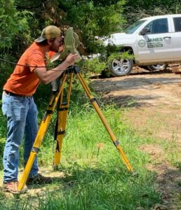
What is a Land Survey?
A land survey is a professional drawing that identifies property boundaries and provides the location of any structures located on the property. Land surveys are extremely important and a necessity for any land owner or prospective land owner. The land survey drawing will depict the four corners of the property and will be marked on the property by a licensed land surveyor. You will use the drawing document and physical markers on the property to establish your property lines or building site.
When do you need a Land Survey?
There are many reasons why you would need a land survey and below are a few examples:
- When purchasing or selling land
- Prior to building a structure
- Resolving a boundary dispute
- Verifying a tax assessment
As you can see, the list of reasons why you need a land survey can be endless. Therefore, hiring a land surveyor is one of the first steps you should take when buying land or building a structure on your property. Look no further than Janes Surveying, Inc. for all of your land surveying needs.
What to expect in a Land Survey from JSI
Every land survey should include property boundaries and the location of buildings, fences, and any existing improvements. It will also depict easements, a description from the property deed, and whether the land is considered in a floodplain.
Most land surveys will include an overview of bordering properties to make sure your property lines are defined correctly. This will eliminate future boundary disputes between landowners.