What is a Real-Time Kinematic (RTK) Survey?
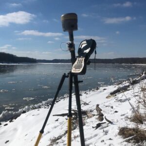
Real-time kinematic, also known as RTK, is a surveying technology which measures the relative positions while using two different Global Navigation Satellite System (GNSS) antennas in real-time with better accuracy. The errors found in GNSS results are decided and fixed using RTK technology. The new generation of intelligent RTK systems provide reception of all available satellite signals. Because of this, slope measurement can be taken without centering and calibration increases productivity by 20%. With this high tech technology, it ensures continuation of a RTK survey incase of temporary interruption of correction signal reception.
RTK is mainly used for construction applications that require higher frequency like cadastral survey, drone navigation, and other construction activities. This technology is unavailable in marine areas, lands with obstructions such as trees, mountains, etc. , or projects that could disrupt communication. The RTK system requires a pre-surveyed base station with known coordinates beforehand.
WHY HIRE JANES AS YOUR SURVEYOR?
As a result of more than 20 years of experience in surveying, Janes Surveying, Inc. is your Palmyra, Missouri survey expert. We are located right here in Palmyra, Missouri and are licensed in Arkansas, Florida, Illinois, Iowa, Kansas, Kentucky, Missouri, North Dakota, South Dakota, Wisconsin. Centrally located, where YOU need us.
We specialize in both residential surveying and commercial surveying. Janes can handle it all. Give us a call today!